

Executive Overview
Puerto Rico’s traditional wet season, which reliably arrives every May to replenish reservoirs, saturate agricultural lands, and sustain local ecosystems, failed to materialize in 2026. Instead of the steady tropical downpours that typically define the late spring and summer months, the U.S. territory experienced a staggering and rapid meteorological shift. By late August 2026, severe and extreme drought conditions had locked their grip on nearly three-quarters of the island, upending daily life, triggering stringent water rationing measures, and inflicting severe economic pain on the agricultural and livestock sectors.
The crisis prompted swift and sweeping administrative actions. In late July, Puerto Rico’s governor declared a formal state of emergency as local water reserves dwindled and municipal supply systems strained under the mounting deficit. By late August, the federal government stepped in, with the U.S. Department of Agriculture (USDA) issuing a formal drought disaster declaration covering more than two dozen cities and towns. This designation opened the door for emergency federal assistance, aiming to bring immediate relief to impacted families, farmers, and ranchers.
Behind the scenes, mapping and tracking this rapid environmental crisis has involved an unprecedented level of technological integration. For the first time in the history of the U.S. Drought Monitor—a collaborative multi-agency partnership dating back to 1999—NASA scientists have directly joined the core group responsible for compiling the weekly assessments. Utilizing an intricate blend of satellite observations, ground-based hydrology networks, and advanced atmospheric modeling, researchers are working around the clock to capture the true geographic extent and severity of the disaster. As climate anomalies become increasingly frequent and erratic in the Caribbean, the intersection of advanced spaceborne Earth observations and frontline emergency management has never been more critical.
Detailed Chronology: From Abundant Rains to Rapid Desertification
To fully comprehend the gravity of Puerto Rico’s 2026 water crisis, one must trace the unusually volatile meteorological timeline that preceded it. The narrative of this drought is not merely one of long-term aridity, but rather of a sudden, violent pendulum swing from hyper-saturation to severe moisture depletion.
Late Winter and Early Spring: A False Sense of Security
The year did not begin with warnings of water scarcity. In fact, throughout the late winter and early spring of 2026, the U.S. Caribbean experienced a wetter-than-normal meteorological regime. According to monitoring reports from the National Integrated Drought Information System (NIDIS), precipitation totals across Puerto Rico were healthy, filling local reservoirs and keeping soils adequately saturated.
During this period, agricultural producers enjoyed favorable planting conditions, and municipal water authorities had little reason to anticipate the impending crisis. As late as May—the historical threshold of the wet season—the U.S. Drought Monitor’s maps showed absolute stability across the island. Not a single square mile of Puerto Rico was classified as being in drought, and less than 20 percent of the territory was even cursorily categorized as abnormally dry.
The Mid-May Turning Point
The weather pattern experienced a jarring reversal almost overnight in mid-May 2026. The expected seasonal monsoonal rains failed to form or push across the region. Instead, persistent high-pressure systems and unfavorable atmospheric steering currents suppressed convective cloud formation and precipitation.
From mid-May through mid-July, the statistical reality of the shift became undeniable. Most of Puerto Rico received less than 60 percent of its normal precipitation during this vital two-month window. In the southern and southwestern sectors of the main island, the drying was even more catastrophic, with these regions recording less than 20 percent of their normal rainfall. This translated to an aggressive and compounding rainfall deficit of 3 to 6 inches (76 to 152 millimeters) over a shockingly brief timeframe.
July: Escalating Emergency and Municipal Strain
By July, the ecological and societal impacts of the rain shortfall could no longer be masked. Temperatures across the island soared, compounding the drying effects of the rainfall deficit. The capital city of San Juan recorded one of its warmest Julys on record, elevating evapotranspiration rates and sucking residual moisture from already parched topsoils.
River levels dropped precipitously. Hydrological stations recorded historic lows in critical waterways, including the Río Fajardo in northeastern Puerto Rico, which serves as a vital ecological and municipal resource. Recognizing the unsustainable trajectory of municipal water supplies, local authorities initiated emergency protocols. By early August, mandatory water rationing schedules were implemented across several municipalities, cutting off taps for hours at a time and forcing residents to adapt to strict conservation routines.
Late August: The Peak of the Crisis and Federal Intervention
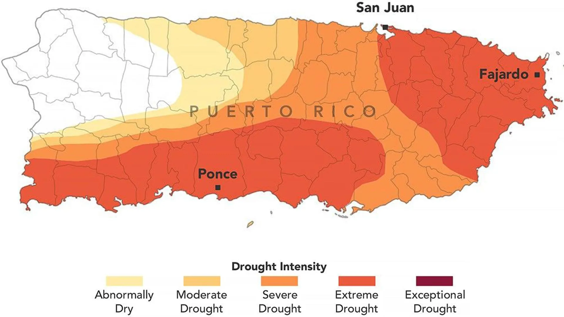
The apex of the meteorological crisis arrived in late August 2026. On August 18 and August 25, updated maps released by the U.S. Drought Monitor painted a grim picture of the territory. Approximately 75 percent of Puerto Rico was experiencing at least moderate drought conditions. More alarmingly, extreme drought zones—denoted by dark orange mapping classifications—had aggressively expanded across the eastern and southwestern sectors of the main island, blanketing a staggering 44 percent of the total territory.
Faced with a mounting humanitarian and economic emergency, the federal response escalated rapidly. In late July, the territorial governor’s emergency declaration was met on August 28 by the USDA’s official drought disaster declaration. This federal safety net was designed to cut through bureaucratic red tape, deploying emergency loans, technical assistance, and feed relief to a population pushed to the brink by an unyielding dry spell.
Supporting Context & Metrics: The Science of the 2026 Drought
The severity of the 2026 event cannot be measured by rainfall totals alone; it is a complex systemic failure of regional hydrology driven by interacting climatic factors.
Geographic Extent and Severity Breakdown
According to the August 25, 2026 U.S. Drought Monitor assessment, the spatial distribution of the drought was heavily skewed toward the island’s geographic extremities.
- Abnormally Dry (D0) to Moderate Drought (D1): Spanned roughly three-quarters of the island’s total land area.
- Severe Drought (D2) to Extreme Drought (D3): Concentrated heavily in the southern, southwestern, and eastern quadrants. The extreme drought (D3) classification alone accounted for 44 percent of Puerto Rico.
This rapid intensification from zero drought coverage in May to 44 percent extreme drought coverage in August represents one of the fastest rates of drought intensification recorded in the modern history of the U.S. Caribbean.
The Hydro-Meteorological Metrics
To understand how dry the landscape became, scientists look at multiple convergent variables:
- Precipitation Deficits: Southern and southwestern regions functioned on less than one-fifth of their standard moisture budget between May and July.
- Soil Moisture Saturation: Root-zone and surface soil moisture metrics derived from microwave satellite sensors dropped to historical minimums, effectively halting vegetative growth cycles.
- Streamflow Anomalies: Gaging stations along major and minor river basins registered flows dipping below the 10th percentile of historical daily values for late summer, signaling depleted shallow groundwater tables and vanishing baseflows.
- Temperature Anomalies: Ambient air temperatures consistently hovered 2 to 4 degrees Fahrenheit above seasonal averages across coastal and urban heat islands like San Juan, accelerating the desiccation of soils and increasing crop water demand.
Infrastructure Vulnerabilities
While the meteorological drought was the primary catalyst, local experts and independent observers have repeatedly noted that Puerto Rico’s aging and vulnerable water infrastructure significantly exacerbated the crisis. Leaky distribution networks, unlined canals, and a historical lack of centralized water storage capacity meant that even when limited water was available, significant percentages were lost before reaching end-users. The combination of meteorological drought and infrastructural strain transformed what could have been a manageable dry spell into a full-scale societal emergency.
Official Statements and NASA’s Expanded Role
The 2026 drought also marks a milestone in how scientific data is integrated into disaster response. The U.S. Drought Monitor—produced jointly by the National Drought Mitigation Center at the University of Nebraska-Lincoln, the USDA, the National Oceanic and Atmospheric Administration (NOAA), and NASA—has long relied on a synthesis of diverse data feeds. However, the 2026 event saw NASA’s institutional footprint expand directly into the operational mapping process.
For years, NASA has supported the drought monitor initiative by providing spaceborne Earth observations, sophisticated hydrological modeling frameworks, and scientific expertise. In 2026, that support transitioned from advisory to active authorship when two prominent NASA scientists joined the small, elite group responsible for producing the weekly drought assessments.
Perspectives from the Frontlines of Earth Science
David Mocko, a senior research scientist in the Hydrological Sciences Laboratory at NASA’s Goddard Space Flight Center, has been at the forefront of this integration. Mocko personally prepared the critical U.S. Drought Monitor update for August 18, 2026. Alongside Jonathan Case of NASA’s Marshall Space Flight Center, Mocko holds the distinction of being among the first NASA scientists to directly author and produce the weekly maps.
Reflecting on the Puerto Rico crisis, Mocko emphasized how clearly the unfolding disaster registered across multiple independent observational layers.
"The effects of the unusually hot and dry conditions were visible across multiple types of satellite and ground-based data used by the U.S. Drought Monitor," Mocko stated.
He highlighted that for localized updates in territories like Puerto Rico, certain data streams are critically important for cutting through geographic blind spots. Specifically, Mocko pointed to high-resolution satellite estimates of root-zone and surface soil moisture, paired with real-time weather station measurements, continuous streamflow tracking, and hydrological observations of agricultural well conditions.
By marrying these space-based assets with ground truth metrics, Mocko, Case, and their colleagues were able to capture the rapid expansion of the D3 (extreme drought) category with pinpoint accuracy, ensuring that federal agencies had the precise data needed to back up emergency policy actions.
Socio-Economic Impacts: Agriculture, Livestock, and Daily Life
The cascading effects of the 2026 drought have spared few sectors of Puerto Rican society, hitting rural producers and urban residents alike.
Agricultural Devastation
For Puerto Rico’s agricultural sector, the timing of the drought could not have been worse. The months of May through August represent a critical growing and fruiting period for many of the island’s signature crops.
- Crops and Orchards: The lack of rain and parched, rock-hard soils severely disrupted the growth cycles of fruit trees, cacao trees, and essential staple crops like bananas and coffee. Agricultural extension agents have reported widespread fruit drop, stunted plant growth, and significant overall crop yield reductions, threatening the livelihoods of generational farmers.
- Livestock and Ranching: Ranchers across the southern and central valleys have faced compounding hurdles. Pastures that should be lush and green during the wet season have withered into brittle, brown stubble. Consequently, livestock owners have watched their local hay supplies dwindle rapidly, forcing many to purchase expensive imported feed or prematurely cull herds to prevent starvation.
Human Toll and Water Insecurity
For urban and suburban residents, the crisis has manifested as an unwelcome disruption to daily routines. With water rationing programs initiated in early August across multiple municipalities, households have had to learn to live with intermittent service.
Queues at public water distribution points, reliance on trucked-in emergency water tanks, and strict household conservation mandates have become the norm. While essential for preserving the remaining water in depleted reservoirs, these measures have placed a heavy psychological and logistical burden on families, particularly in lower-income communities lacking private cistern infrastructure.
Future Outlook and Resilience Strategies
As Puerto Rico moves past the peak of the 2026 summer dry period and looks toward the remainder of the Atlantic hurricane season—which traditionally brings both flood risks and much-needed tropical moisture—questions linger about long-term climate resilience.
The rapid intensification of the 2026 drought serves as a stark reminder of the increasing volatility of Caribbean precipitation patterns under a changing global climate. Climatologists warn that while individual drought events are driven by specific regional weather anomalies, the baseline trend points toward higher ambient temperatures and more erratic rainfall distributions across the Caribbean basin.
To mitigate future crises of this magnitude, federal, territorial, and local stakeholders are emphasizing the urgent need for structural modernization. Key areas of focus include:
- Infrastructure Overhaul: Upgrading leaky municipal distribution networks to minimize water loss before it reaches the consumer.
- Enhanced Storage Capacity: Expanding off-stream water storage and improving the maintenance of existing reservoirs.
- Data-Driven Agriculture: Expanding the deployment of soil moisture sensors and promoting drought-resistant crop varieties among local farmers.
- Institutional Integration: Continuing the deep collaboration between space agencies like NASA and local emergency management planners, ensuring that real-time Earth observation data continues to drive rapid, preemptive policy responses.
Ultimately, while the 2026 drought has left deep scars on Puerto Rico’s landscape and economy, the integration of advanced satellite science and decisive administrative action has laid a robust foundation for weathering future environmental extremes.
