

Executive Overview
The American Southwest is facing an escalating ecological and infrastructural emergency as decades of chronic dryness collide with acute seasonal anomalies. In 2026, a severe "snow drought" coupled with unusually persistent high temperatures across the Colorado River Basin sharply curtailed the water supplies feeding the western United States’ vital reservoir network. By late summer, the compounding effects of a weak 2025–2026 winter snowpack drove both Lake Powell and Lake Mead—the nation’s two largest water storage facilities—to unprecedented, record-low levels.
This dramatic decline threatens the water security and economic vitality of a vast region. More than 40 million people across major metropolitan areas, including Las Vegas, Phoenix, Los Angeles, and San Diego, depend directly on the Colorado River system for municipal water and clean energy. Additionally, the river irrigates roughly 5 million acres of vital agricultural land that anchors the domestic food supply.
As water levels breached previous historical floors, federal agencies, tribal governments, and academic institutions scrambled to manage the crisis. Through emergency releases, canceled environmental flows, and advanced satellite monitoring, stakeholders are fighting to protect critical infrastructure from catastrophic failure. Yet, beneath these stopgap measures lies a sobering reality: the 21st-century megadrought shows no signs of abating, forcing the American West into an era of permanent water scarcity that demands fundamental shifts in how the region’s most precious resource is managed, conserved, and monitored.
Detailed Chronology of the 2026 Basin Crisis
The descent of the Colorado River system into historic lows in 2026 was not a sudden catastrophe, but rather the culmination of a deteriorating hydrological trajectory that accelerated rapidly during the winter and summer months.
The Winter of 2025–2026: The Onset of the Snow Drought
The seeds of the 2026 water crisis were sown during the winter months of late 2025 and early 2026. The Upper Colorado Basin—along with numerous mountainous regions spanning the broader U.S. West—experienced a profoundly disappointing accumulation of winter precipitation. Instead of building a robust, deep snowpack capable of sustaining the river through the dry summer months, high-elevation areas received a fraction of their historical averages.
Compounding this lack of precipitation were periods of abnormal, record-setting warmth across the basin. These unseasonably high temperatures prevented the accumulation of meaningful snow reserves and initiated premature melting events. Consequently, the spring snowmelt, which historically serves as the primary lifeblood of the Colorado River, arrived early and delivered a vastly diminished volume of water to downstream channels and reservoirs.
Spring 2026: Emergency Interventions at Lake Powell
Recognizing the unfolding disaster, the U.S. Bureau of Reclamation (USBR) initiated critical operational shifts in April 2026. Federal water managers confronted a terrifying prospect: without immediate intervention, Lake Powell’s water surface elevation risked dropping below the minimum threshold required to maintain hydroelectric power generation at the Glen Canyon Dam by August 2026.
To stave off this scenario, the USBR enacted emergency protocols. The agency began releasing additional water volumes from the Flaming Gorge Reservoir, located upstream in northern Utah and southern Wyoming, to prop up Lake Powell’s declining levels. Simultaneously, managers restricted downstream releases from Lake Powell into Lake Mead to slow the bleeding of the upper reservoir.
These emergency maneuvers came at a steep environmental cost. In April 2026, the USBR officially canceled a planned "controlled flood" designed to rebuild downstream sandbars and maintain critical fish habitats. Later in August, officials also skipped a scheduled "cool mix" water release intended to regulate river temperatures and protect native aquatic species. These cancellations underscored the agonizing trade-offs water managers faced as they prioritized basic human supply and hydropower generation over river ecosystem health.
Summer 2026: Crossing the Threshold at Lake Powell and Lake Mead
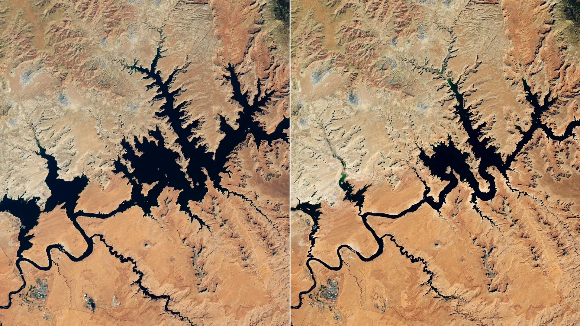
By mid-summer, the full impact of the weak snowpack reached the expansive body of Lake Powell. Inflow volumes plummeted to historic lows. Satellite imagery captured by the Operational Land Imager (OLI) aboard the joint NASA-USGS Landsat 8 satellite starkly illustrated the transformation, offering side-by-side comparisons with wetter years past.
On September 10, 2026, satellite data and on-the-ground gauges recorded Lake Powell’s water surface standing at an alarming 3,517.24 feet. This figure breached the reservoir’s previous modern record low of 3,519.92 feet, which had been set just a few years prior on April 13, 2023. Even before this September milestone, the lake had already slipped below that previous historical floor in late July and early August, continuing a relentless downward spiral into early autumn.
Because the Colorado River flows sequentially from the Upper Basin through Lake Powell before continuing downstream toward Lake Mead, the upper reservoir’s woes quickly cascaded. By August 2026, Lake Mead reached record-low levels of its own, dragging the entire interconnected river system down into uncharted territory.
Supporting Context & Metrics
Understanding the severity of the 2026 crisis requires examining the unique hydrological mechanics of the Colorado River Basin and the sheer scale of human reliance on its waters.
Why Snow Matters: The Mechanics of the Basin
Much of the geographic expanse covered by the Colorado Basin is classified as arid or semi-arid terrain, receiving minimal annual rainfall at lower elevations. As a result, the region’s hydrology is uniquely dependent on high-elevation winter snowpack—a phenomenon often referred to as a "natural water tower."
A substantial share of the Colorado River’s annual flow originates as snow that accumulates on rugged mountain peaks during the winter months. When spring and early summer arrive, this snowpack melts gradually, releasing a steady, predictable supply of water into tributaries that feed the main stem of the Colorado River. When winter fails to deliver adequate snowfall, or when unseasonable warmth melts the pack prematurely, the entire hydrological system is starved of its primary input, leaving reservoirs with little capacity to buffer against multi-year dry spells.
The Human and Economic Footprint
The Colorado River is arguably the most heavily regulated, litigated, and hard-working river system in the world. Managed jointly by the USBR, state authorities, and tribal nations, the river sustains an economic engine of extraordinary proportions:
- Population Center Support: More than 40 million residents across the American Southwest depend on the river for municipal drinking water and sanitation. This includes massive metropolitan populations in Las Vegas, Phoenix, Los Angeles, and San Diego.
- Agricultural Powerhouse: The river supplies essential irrigation water to approximately 5 million acres of rich farmland across multiple states. This agricultural output produces a significant portion of the nation’s winter vegetables, fruits, and livestock feed, tying the security of the American food supply directly to the health of the basin’s reservoirs.
- Hydropower Generation: Facilities like the Glen Canyon Dam (Lake Powell) and Hoover Dam (Lake Mead) generate critical carbon-free hydroelectric power for millions of homes and businesses, a capacity that is severely jeopardized when water levels drop toward minimum power pool elevations.
Official Statements and Management Responses
Federal, state, and tribal authorities have responded to the 2026 crisis with a mix of aggressive operational adjustments and investments in cutting-edge monitoring technology.
Federal and Regional Adjustments
The U.S. Bureau of Reclamation has borne the brunt of the operational burden, balancing conflicting mandates under the Law of the River. By prioritizing upstream storage transfers from Flaming Gorge and constricting outflows to Lake Mead, federal managers have demonstrated a willingness to take unprecedented administrative actions to prevent infrastructural collapse at Glen Canyon Dam. However, these moves have drawn intense criticism from environmental organizations and conservation groups, who point out that halting controlled floods and cool-water releases inflicts severe, compounding damage on native ecosystems and endangered fish populations within the Grand Canyon corridor.
Technological Innovation in Drought Monitoring
To navigate this ongoing crisis, water managers are increasingly relying on advanced, NASA-supported monitoring platforms that provide unprecedented real-time visibility into basin-wide conditions:
- Western Land Data Assimilation System (WLDAS): Positioned at the headwaters of the Colorado River, a dashboard built around the WLDAS framework delivers real-time visualizations of critical hydrological metrics, including soil moisture, snow water equivalent (SWE), and evapotranspiration rates. This high-resolution data directly supports Colorado’s dedicated drought task force and feeds vital data into the weekly U.S. Drought Monitor maps.
- Drought Severity Evaluation Tool: Developed in close collaboration with the Navajo Nation and funded by NOAA’s National Integrated Drought Information System (NIDIS), this tool enables tribal leaders to track localized drought indicators, shifting precipitation regimes, and vegetation health across extensive tribal lands. Following its successful adoption, its usage expanded in 2025 to include Oklahoma’s Chickasaw and Choctaw Nations.
- Colorado River Integrated Assessment Tool: Created through a strategic partnership between Arizona State University researchers and the Central Arizona Project, this comprehensive system synthesizes sophisticated computer modeling with NASA-satellite-validated measurements. It consolidates snowpack dynamics, surface and groundwater storage volumes, and soil moisture data into a single, interactive decision-support platform for basin-wide managers.
Future Outlook
The historic lows recorded at Lakes Powell and Mead in the summer of 2026 are not an isolated anomaly, but rather the latest milestone in a prolonged, multi-decadal drying trend. Climatologists and hydrologists widely agree that the U.S. Southwest has been gripped by a sprawling "megadrought" since the dawn of the 21st century—a dry epoch unrivaled in severity for at least 1,200 years.
As temperatures continue to rise globally, the baseline hydrology of the Colorado River Basin is undergoing a permanent structural shift. Higher ambient temperatures mean a greater percentage of precipitation falls as rain rather than snow, and what snow does accumulate melts earlier and faster, accelerating evaporative losses from reservoirs before the water can even be captured and managed.
For the 40 million citizens, tribal communities, and agricultural producers who rely on the basin, the message from the 2026 crisis is unmistakable: the margin for error has vanished. While emergency water transfers, environmental sacrifices, and high-tech satellite monitoring tools provide essential breathing room, they are ultimately stopgaps.
Securing the long-term future of the American Southwest will require permanent reductions in water consumption, modernized interstate compacts, accelerated agricultural efficiency, and a collective acknowledgment that the Colorado River of the 21st century cannot support the unbridled consumption patterns of the past. Without fundamental transformation, the record lows of 2026 will soon be remembered not as the absolute bottom, but merely as a waystation on the path toward a drastically reshaped western landscape.