

Executive Overview
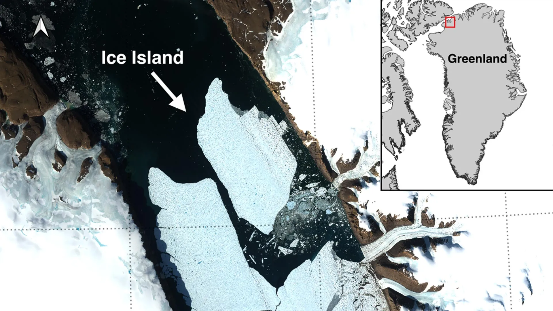
In the remote expanses of northwest Greenland, a monumental fracture of the cryosphere has redefined the geopolitical and scientific landscape of the high north. On August 4, 2026, an international coalition of glaciologists and polar researchers documented a catastrophic calving event at the Petermann Glacier—one of the region’s last remaining giant floating ice tongues. The glacier shed a staggering 76.4-square-kilometer tabular iceberg, an expanse roughly comparable to the total land area of Manhattan Island.
This historic rupture marks the most substantial loss of floating ice from the Petermann Glacier since 2012, and the largest single Arctic calving event recorded anywhere in the polar north since 2020. Rising as much as 150 meters thick, the newly liberated ice island stands as a colossal monument to accelerating climate instability at the top of the world. While tabular icebergs of this magnitude are a familiar spectacle in the Southern Ocean surrounding Antarctica, they are extraordinarily rare in the Arctic. Consequently, this event presents an unprecedented, high-stakes natural laboratory for the international scientific community.
The discovery was spearheaded by Adam Garbo, a doctoral researcher specializing in glaciology within the Department of Geography, Environment and Geomatics at the University of Ottawa (uOttawa). Garbo identified the break through rigorous, long-term satellite monitoring conducted as part of a multi-institutional research initiative. This ongoing cooperative effort brings together experts from the University of Ottawa, the University of Stirling, Environment and Climate Change Canada (ECCC), Lancaster University, and the University of Leeds.
Beyond its academic significance, the calving carries immediate practical implications. The newly formed ice island—alongside two additional massive sections teetering on the edge of the glacier—poses a lingering, multi-year hazard to Arctic navigation, indigenous subsistence routes, and emerging offshore resource infrastructure. As government agencies and academic institutions mobilize to track the frozen monolith’s trajectory, the Petermann Glacier event serves as an urgent reminder of the profound transformations reshaping Earth’s polar ice sheets.
Detailed Chronology: Anatomy of a Fracture
The birth of the 76.4-square-kilometer ice island was not a sudden, random catastrophe, but rather the violent culmination of years of structural fatigue, thermal stress, and mechanical fracturing. To understand how the ice tongue finally yielded on August 4, 2026, researchers must look back through a meticulously documented timeline of satellite observations, stress accumulation, and structural deterioration.
Years of Growing Instability (2019–2025)
The story of the 2026 calving event began years prior. Since 2019, glaciologists have maintained an unbroken, high-resolution vigil over the Petermann Glacier’s floating ice tongue utilizing advanced spaceborne radar and optical imaging systems. During this multi-year window, scientists observed the steady, methodical expansion of complex fracture networks across the ice tongue’s centerline.
As warm ocean currents intruded into the deep fjords of northwest Greenland, they began eating away at the underside of the glacier, thinning the floating tongue from below. Simultaneously, surface meltwater pooled in structural depressions, forcing its way down into crevasses through a process known as hydro-fracturing. These twin forces—basal melting and internal hydraulic pressure—acted as a slow-motion wedge, driving deep rifts progressively deeper into the structural core of the glacier.
By late 2025, researchers monitoring the telemetry and satellite feeds realized that the ice tongue had reached a critical tipping point. The structural integrity of the eastern margin was severely compromised, held together by increasingly narrow, strained ribbons of ice.
The Final Hours: August 3–4, 2026
The definitive sequence of the breakup unfolded over a tense 48-hour period in early August. On August 3, 2026, radar imagery captured by the European Space Agency’s (ESA) Sentinel-1 mission revealed unmistakable signs of catastrophic deterioration along the centerline of the Petermann ice tongue. The fractures, which had spent years widening by centimeters, suddenly dilated exponentially as internal resistive stresses overcame the tensile strength of the remaining ice bridges.
By 20:00 UTC on August 4, the tipping point was crossed. The massive tabular iceberg fully sheared away from the glacier’s eastern flank, groaning as millions of tons of ancient glacial ice broke free into the fjord. The newly independent ice island immediately began to rotate and drift slightly away from its parent glacier, opening up a wide expanse of open dark water where a continuous sheet of white had stood just hours prior.
Adam Garbo, who caught the initial signs of the break, noted the historical weight of the observation. "Petermann Glacier has long been one of Greenland’s largest remaining ice tongues," Garbo reflected. "We’ve anticipated this break for years, and seeing it finally happen is remarkable—both for the sheer scale of the physics involved and for what it tells us about the trajectory of polar change."
Supporting Context & Metrics: Understanding the Scale
To fully comprehend the magnitude of the Petermann Glacier calving event, one must contextualize its physical dimensions, geographic rarity, and the alarming trajectory of future losses projected by the scientific team.
Physical Dimensions and Geographic Rarity
The newly calved ice island is a monolithic block of compressed, ancient snowfall. Spanning an area of 76.4 square kilometers, its footprint is roughly equivalent to Manhattan Island. More impressive still is its vertical dimension: scientists estimate the tabular iceberg plunges as much as 150 meters deep from its flat surface to its submerged keel.
In the polar regions, icebergs generally fall into two categories: jagged, irregular bergs born of tidewater glaciers, and massive, flat-topped tabular icebergs born of ice shelves and floating ice tongues. While tabular icebergs are a relatively common occurrence in the Southern Ocean surrounding the Antarctic Ice Sheet—where massive shelves regularly calve city-sized blocks—equivalent "ice islands" are exceptionally rare in the Arctic.
This scarcity is driven by the geography of the Arctic, where floating ice shelves are far smaller and more constrained by surrounding landmasses than their Antarctic counterparts. Because Arctic ice islands are so rarely produced, each occurrence offers a unique, high-value natural laboratory for researchers. They provide a rare window into the mechanics of polar ice shelf retreat, the response of glaciers to warming ocean waters, and the hydrodynamic behavior of colossal ice masses as they interact with coastal currents and bathymetry.
The Looming Threat: Projected Future Calvings
Compounding the significance of the August 4 event is the unsettling realization that the Petermann Glacier is far from finished shedding ice. The same rifts and stress networks that precipitated the recent break have continued to propagate across the remainder of the floating ice tongue.
According to predictive models and current satellite tracking data, glaciologists anticipate two additional large-scale calving events in the near future. These impending separations involve two massive sections of the ice tongue that are already deeply fractured:
- Projected Break #1: Approximately 94 square kilometers in surface area.
- Projected Break #2: Approximately 84 square kilometers in surface area.
When combined with the August 4 event (76.4 $km^2$), these three successive calvings will strip a staggering 254 square kilometers of ice from the Petermann Glacier’s floating tongue. This cumulative loss will reduce the overall surface area of the ice tongue by approximately 22 percent, fundamentally altering the geometry and stability of one of Greenland’s premier glacial outlets.
Official Statements and Institutional Collaboration
The documentation, analysis, and ongoing monitoring of the Petermann Glacier event are the direct result of a tightly coordinated international partnership. By pooling resources across academic institutions and governmental agencies, researchers have transformed a remote geographic anomaly into a thoroughly studied data-rich event.
Academic Insights: Bridging the Polar Divide
Dr. Anna Crawford of the University of Stirling, an expert in polar glaciology and ice-ocean interactions, emphasized the broad scientific utility of studying Arctic ice islands.
"While large, tabular icebergs are relatively common in the Southern Ocean that surrounds the Antarctic Ice Sheet, Arctic ice islands are far rarer," explains Dr. Crawford. "By studying Arctic ice islands, we will gain knowledge that can be transferred across polar regions. The physical processes governing how these massive blocks fracture, drift, and interact with warming oceans are fundamentally universal, yet studying them in the Arctic provides unique insights into how northern ecosystems are adapting to rapid climate acceleration."
The research collaborative—spanning uOttawa, the University of Stirling, Lancaster University, and the University of Leeds—combines field observations, numerical modeling, and high-cadence satellite remote sensing to construct comprehensive models of ice shelf vulnerability.
Marine Safety and Operational Risk
While glaciologists view the event through the lens of earth systems science, operational agencies like Environment and Climate Change Canada (ECCC) and the Canadian Ice Service (CIS) view the newly birthed ice island through the critical framework of public safety and maritime commerce.
Dr. Abigail Dalton of the Canadian Ice Service, ECCC, highlighted the long-term navigational hazards associated with massive Arctic ice islands.
"These are immensely thick blocks of ice that can drift intact for years," specifies Dr. Dalton. "Over time, as they move southward through polar channels, they gradually fracture into smaller, harder-to-track pieces. These smaller remnants pose severe, lingering hazards to commercial vessels, fishing fleets, and offshore resource operations operating in northern waters."
Because the Canadian Ice Service has extensive experience monitoring ice shelf fragmentation following previous Arctic calving events—such as those observed at the Milne Ice Shelf—they have already initiated specialized tracking protocols. Using a combination of RADARSAT constellations, scatterometer data, and oceanographic drift models, ECCC is maintaining a continuous watch on the 76.4-square-kilometer island to project its hazardous trajectory over the coming months and years.
Future Outlook: The Road Ahead for Petermann Glacier
As the dust—and ice—settles following the historic August 4 event, the international scientific community is shifting its focus to the future. The immediate aftermath of the Petermann Glacier calving is marked by an intensive, multi-pronged research campaign.
Adam Garbo and his uOttawa collaborators, working alongside their institutional partners, have laid out an aggressive monitoring agenda. The team plans to leverage high-resolution satellite imagery, targeted aerial observations where feasible, and autonomous buoy tracking data to follow the ice island’s long-term journey.
This ongoing surveillance is not merely an academic exercise. It forms a crucial component of a broader, global scientific effort to decode the complex feedback loops driving the rapid retreat of Arctic ice shelves. As greenhouse gas concentrations continue to alter atmospheric and oceanic circulation patterns, glaciers like Petermann serve as early-warning indicators for the stability of the entire Greenland Ice Sheet.
The loss of 76.4 square kilometers of ice in a single day is a stark manifestation of a changing planet. Yet, through the tireless efforts of researchers in Ottawa, Stirling, Lancaster, Leeds, and Ottawa’s government laboratories, humanity is gaining an unprecedented, clear-eyed view of the mechanics behind the thaw. As the remaining fracture zones on the Petermann ice tongue continue to widen, the world watches and waits for the next monumental chapter in the evolution of the Arctic cryosphere.
