

Executive Overview
Tropical peatland fires represent one of the most insidious, dangerous, and resilient natural disasters on Earth. Unlike conventional forest fires that race frantically through tree canopies and surface vegetation, tropical peat fires smolder persistently through dried wetland soils and ancient, carbon-dense deposits of decomposed organic matter. Burning deep underground at relatively low temperatures, these subterranean infernos are notoriously difficult to extinguish, frustrating the efforts of frontline firefighters and generating massive volumes of toxic, polluting haze.
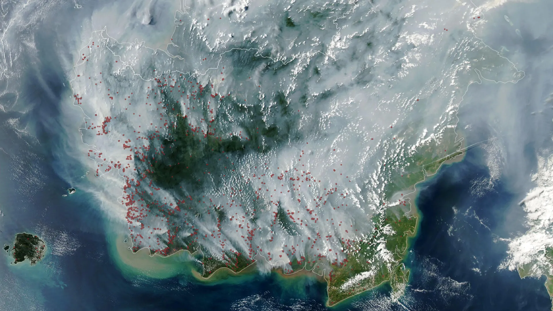
As Indonesia moves into the early weeks of its 2026 dry season, alarm bells are ringing across the international scientific and meteorological communities. Satellite monitoring instruments operated by NASA and NOAA have recorded an alarming upward trajectory in thermal anomalies across the region’s vast carbon sinks. Driven by a strengthening El Niño climate pattern and compounded by a positive phase of the Indian Ocean Dipole, the early weeks of the 2026 fire season are tracking uncomfortably close to the catastrophic levels observed during the historic 2015 crisis.
The consequences of this unfolding crisis extend far beyond local air quality. Peatlands act as vital global carbon sinks; when they burn, they release millennia of stored greenhouse gases back into the atmosphere in a matter of weeks. With millions of Indonesians already experiencing hazardous air quality, schools shifting to remote learning, national parks closing, and flights grounded, the 2026 fire season has transformed into an immediate humanitarian and environmental emergency. Furthermore, it serves as a high-stakes stress test for the restoration policies and fire-mitigation frameworks implemented by the Indonesian government in the wake of past disasters.
Detailed Chronology: The Anatomy of the 2026 Crisis
The unfolding disaster in Indonesia is not a sudden anomaly; it is the culmination of seasonal shifts, severe meteorological precursors, and decades of ecological modification.
The Pre-Season Drought and Early Ignition
By mid-summer 2026, the foundational elements for a severe fire season were firmly in place. Data compiled by the Indonesian meteorological agency revealed that approximately 90 percent of the archipelago received little to no rainfall during early August. This widespread, severe drought stripped the normally waterlogged landscapes of their moisture, setting the stage for combustion.
As early as August 31, 2026, the Indonesian Ministry of Forestry’s SiPongi fire-monitoring platform—utilizing data from the MODIS and VIIRS satellite instruments—recorded 946 active hotspots across the country. By September 1, the MODIS instrument aboard NASA’s Aqua satellite captured sweeping images of the burgeoning fire season, mapping dense clusters of thermal anomalies across key carbon-rich provinces.
The Accelerating Emissions Trajectory
The speed at which the 2026 fires have escalated has alarmed researchers who monitor global carbon emissions. Robert Field, a research scientist at Columbia University and developer of the Global Fire Weather Database (GFED), noted that the current season is mirroring the devastating trajectory of 2015.
To understand the gravity of this comparison, one must look back at the historical benchmark. After more than three months of relentless burning in 2015, Indonesian fires emitted an estimated 1.75 billion tons of greenhouse gas equivalents—surpassing the total annual greenhouse gas emissions of an industrialized nation like Japan. By September 2, 2026, after burning for roughly a month, the current season had already released approximately 10 percent of that staggering 2015 total. Without substantial intervention or the arrival of early seasonal rains, cumulative emissions threaten to reach catastrophic proportions.
Supporting Context & Metrics: The Science of Peat and Atmospheric Pollution
To fully comprehend the threat posed by Indonesia’s fires, one must understand the unique composition and behavior of tropical peatlands. Indonesia holds approximately 36 percent of the world’s tropical peatlands, primarily distributed across the provinces of Kalimantan, Sumatra, and Papua.
Why Peat Fires Are Uniquely Dangerous
Under normal, healthy conditions, these peat deposits are saturated with water, keeping the organic matter perpetually wet and impervious to fire. However, severe droughts lower the water tables, transforming the sponge-like terrain into dry fuel.
Once ignited, surface vegetation fires can breach the topsoil and transition into subterranean peat fires. Because these fires burn below the surface, they are shielded from direct rainfall and standard aerial firefighting tactics.
"Surface fires are less of a concern, but when fires get underground, they just won’t stop," explains Robert Field. "They’ll keep burning until the rains come in October or November."
The Chemical Signature of Peat Smoke
The atmospheric emissions generated by burning peat are vastly more toxic than those produced by standard forest or brush fires. Scientific estimates indicate that tropical peat fires produce:
- Three times more fine particulate matter ($textPM_2.5$) than other tropical forest fires.
- Five times more sulfur dioxide ($textSO_2$).
- Three times more organic carbon.
- Twice as much methane ($textCH_4$) and carbon monoxide ($textCO$).
This potent cocktail of pollutants creates a persistent, choking haze that reduces visibility, causes widespread respiratory and cardiovascular distress, and blankets neighboring countries in toxic smog.
Historical Precedents: El Niño and the Indian Ocean Dipole
Wildfires occur in Indonesia on an annual cycle during the dry season, but the most economically and ecologically devastating episodes consistently correlate with major climate anomalies. The most destructive seasons in recent history—notably 1997 and 2015—occurred during strong El Niño cycles.
In August 2026, the National Oceanic and Atmospheric Administration (NOAA) formally assessed El Niño as present and strengthening. This climate phenomenon systematically suppresses rainfall across the Indonesian archipelago. The desiccation of the landscape was further intensified by the concurrent presence of a positive phase of the Indian Ocean Dipole, creating a compounding climatic squeeze that expedited the drying of sensitive wetland ecosystems.
The Blind Spots of Space-Based Monitoring
While satellites are indispensable tools for tracking global disasters, monitoring Indonesian peat fires presents a severe technological paradox. The primary instruments relied upon by agencies worldwide—such as MODIS (Moderate Resolution Imaging Spectroradiometer) and VIIRS (Visible Infrared Imaging Radiometer Suite)—identify thermal anomalies and active hotspots from orbit. However, these systems face distinct limitations:
- Obfuscation by Smoke: When fires become intensely active, the resulting plumes of thick, dense smoke can completely block the line of sight of optical and infrared sensors. Ironically, the worst smoke events are frequently the hardest to observe from space.
- Subsurface and Understory Blinds: Satellites struggle to detect fires that smolder deep underground within peat layers or creep quietly beneath thick forest canopies.
Reflecting on these diagnostic hurdles, Dr. Mark Cochrane, an ecologist at the University of Maryland Center for Environmental Science who has studied Indonesian peat fires for a decade, noted: "The worst smoke events, paradoxically, can be the hardest to observe from space with MODIS and VIIRS."
Official Statements & Technological Innovations
Historical Roots of Vulnerability
The modern vulnerability of Indonesia’s peatlands is not purely a product of natural climate cycles; it is heavily influenced by historical land-use policies. During the 1990s, extensive construction of irrigation canals and the large-scale drainage of peat swamps—undertaken in part to facilitate massive agricultural initiatives like the failed Mega Rice Project—drastically altered the hydrology of the region. By lowering water tables across millions of hectares of wetland, these projects dried out the landscape and transformed carbon sinks into highly combustible powder kegs. The subsequent expansion of oil palm plantations and industrial forestry further entrenched these vulnerable hydrological conditions.
Following the devastating 2015 fire season, government bodies, international researchers, and non-governmental organizations launched concerted efforts to reverse ecological degradation. Remediation projects focused on blocking unauthorized drainage canals to re-wet peatlands, enhancing local firefighting infrastructure, and enforcing stricter penalties for illegal land-clearing and agricultural burning.
The 2026 Stress Test
The unfolding events of 2026 represent an unprecedented test of these post-2015 reforms.
"This year will be a real stress test of the measures that were put in place after 2015," observes Shi Jun Wee, a graduate student and researcher at the University of Maryland.
Wee is part of an international scientific coalition collaborating with NASA and MapBiomas to pioneer advanced detection methodologies. By harnessing shortwave infrared observations from high-resolution satellites like Landsat and Sentinel-2, researchers are developing systems capable of identifying understory and smoldering fires that historically evaded MODIS and VIIRS detection.
Throughout the 2026 season, researchers are tracking these developments via advanced data platforms, including NASA’s Worldview data browser, FIRMS (Fire Information for Resource Management System), HLS (Harmonized Landsat and Sentinel-2) observations, and the Global Fire Emissions Database (GFED).
Future Outlook: Breaking the Cycle of Apathy
As the 2026 dry season deepens, the immediate human cost is mounting. Indonesian authorities have issued widespread health warnings as hazardous smoke blankets populated islands. In response to the deteriorating air quality, educational institutions in heavily impacted provinces have transitioned to remote learning to protect children from toxic particulate exposure. Additionally, authorities have closed nine national parks to prevent accidental ignitions, and regional aviation has experienced intermittent flight delays due to severely restricted visibility.
However, researchers warn that the international community suffers from a recurring cycle of reactive panic and proactive amnesia.
"People tend to focus on these fires during an El Niño and then forget about them," warns Mark Cochrane. "We need sustained focus, even during the years when they aren’t as bad, to solve this. These fires create a tremendous amount of emissions."
Path Forward
Mitigating the existential threat of tropical peatland fires requires a permanent, multi-faceted commitment that transcends seasonal weather patterns. Key imperatives moving forward include:
- Aggressive Hydrological Restoration: Continuing and expanding canal-blocking and re-wetting projects across drained peat domes to prevent subterranean drying.
- Advanced Monitoring Integration: Incorporating high-resolution shortwave infrared satellite data to detect underground and understory fires before they breach containment thresholds.
- Sustained International Financing: Securing long-term funding for local enforcement, community-based fire prevention, and sustainable agricultural alternatives that do not rely on slash-and-burn clearing methods.
Without unwavering, multi-year investments in landscape resilience, Indonesia’s peatlands will remain a ticking carbon bomb—detonating with every major El Niño cycle, threatening regional public health, and accelerating global climate destabilization.