

ARCTIC CIRCLE — Summer in Greenland’s glacier-fed fjords is a season of transformation, defined by the thunderous rupture of ancient ice meeting the sea. But even in a region accustomed to dramatic seasonal changes, the events of August 2026 stand out as a watershed moment for polar glaciology.
A monumental calving event at the Petermann Glacier on Greenland’s rugged northwest coast has sent a floating ice island roughly the size of St. Thomas in the U.S. Virgin Islands drifting into the Arctic waters. Spanning an area of just over 76 square kilometers (29 square miles), this colossal tabular iceberg marks the single largest calving event from any Arctic glacier since 2020.
While iceberg calving is a natural and expected phase in the life cycle of marine-terminating outlet glaciers, this occurrence has sent ripples through the international scientific community. Petermann Glacier acts as a critical hydraulic and structural gatekeeper, regulating the massive flow of ice from the interior Greenland Ice Sheet out into the open ocean. Consequently, tracking its stability, fracture patterns, and long-term health offers vital clues for global sea-level rise projections.
This in-depth investigative report examines the timeline of the August 2026 calving, the high-tech monitoring methods used by researchers, the dramatic physics of the iceberg’s collision with Joe Island, and the broader environmental implications for global sea levels and maritime safety.
Executive Overview
The dramatic birth of the 2026 Petermann ice island underscores the rapidly shifting dynamics of the Arctic cryosphere. Caught on high-resolution satellite imagery on August 4, 2026, the massive slab of ice broke free from the glacier’s expansive floating ice tongue. Measuring 76 square kilometers, it is the largest tabular iceberg to detach from Petermann since the staggering 2012 event, which produced an ice island covering 130 square kilometers.
However, the sheer size of the newly formed iceberg tells only part of the story. Glaciologists monitoring the region had anticipated an even more catastrophic fracture. Advanced remote-sensing data captured by doctoral researchers and veteran scientists revealed a complex web of deep rifts crisscrossing the glacier’s ice tongue. To the surprise of the research community, the glacier bypassed these heavily monitored fault lines, fracturing along an entirely different trajectory.
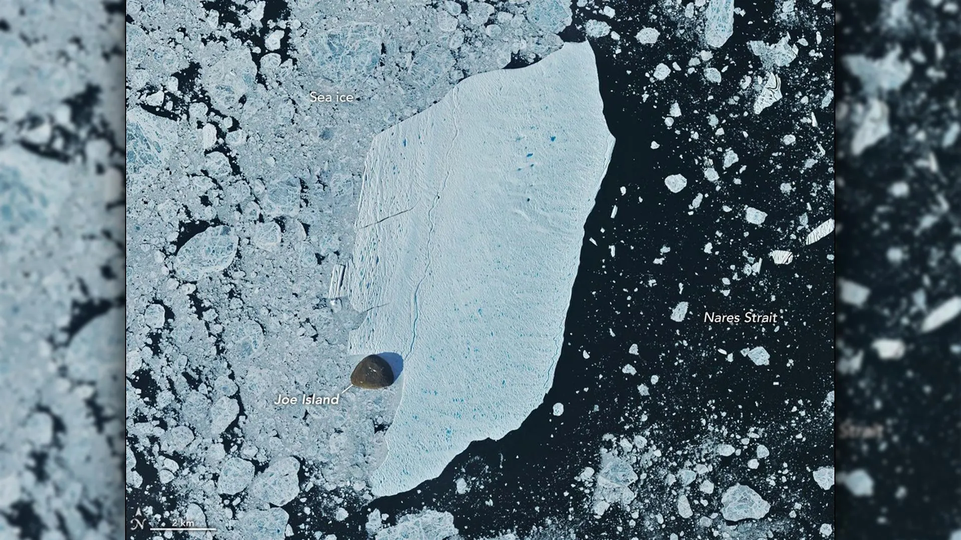
Following its separation, the gargantuan ice island embarked on a hazardous journey down the Petermann Fjord, driven by coastal winds and surface currents at an average clip of 3 kilometers per day. Its path immediately intersected with Joe Island, a small rocky outcrop strategically positioned at the mouth of the fjord. The resulting high-stakes collision—captured in stunning detail by spaceborne optical instruments—pitted the fragile, flat-topped monolith against an immovable obstacle.
To the astonishment of observers, the ice island survived the impact structurally intact, pivoting away from the outcrop and entering the treacherous currents of Nares Strait. As it drifts south toward Baffin Bay, researchers warn that its eventual breakup will send thousands of hazardous fragments into vital Arctic shipping lanes, while pumping millions of gallons of freshwater into the marine ecosystem.
Detailed Chronology: From First Crack to Open Waters
Early August 2026: The Initial Detection
The unfolding drama at Petermann Glacier was first brought to light on August 4, 2026, by Adam Garbo, a doctoral student in glaciology at the University of Ottawa. Utilizing continuous radar imagery from the European Space Agency’s Sentinel-1 mission, Garbo spotted the sudden structural failure of the glacier’s floating ice tongue.
Garbo, alongside an international coalition of remote-sensing experts, has spent years tracking the delicate morphology of Petermann’s tongue. Unlike grounded glaciers that terminate directly on solid rock, Petermann features an expansive, floating tongue of ice that extends far out into the fjord. This tongue acts as a stabilizing buttress, holding back the immense weight of the upstream ice sheet. When a major fracture occurs, the structural integrity of the entire system is temporarily compromised.
Mid-August 2026: The Fjord Transit and the Joe Island Collision
Once liberated from the parent glacier, the 76-square-kilometer ice island did not remain stationary. Guided by katabatic winds and surface currents, the berg began a steady downstream migration toward Nares Strait, covering an average of 3 kilometers (nearly 2 miles) per day during its inaugural week.
Tracked meticulously by veteran glaciologist Mauri Pelto of Nichols College using NASA-USGS Landsat satellite data, the iceberg’s trajectory placed it on a direct collision course with Joe Island (Joe Île). Situated near the entrance of Petermann Fjord, Joe Island has long served as a geographic anvil for massive ice islands escaping the fjord.
Historical precedent suggested that this encounter would prove fatal to the integrity of the ice island. In 2010, a much larger Petermann ice island struck the exact same rocky outcrop and violently split into two distinct pieces.
On August 23 and 24, 2026, the Operational Land Imager (OLI) aboard the Landsat 9 satellite captured breathtaking imagery of the collision. The flat-topped monolith made direct contact with Joe Island, prompting glaciologists worldwide to hold their breath. Yet, defying expectations, the ice island absorbed the kinetic energy of the impact without succumbing to catastrophic fragmentation. By late August, satellite observations confirmed that the berg had successfully pivoted away from the outcrop, swinging its massive bulk southwestward into the churning channels of Nares Strait.
Supporting Context & Metrics: Anatomy of a Calving Event
To fully grasp the magnitude of the 2026 Petermann calving event, it is essential to place it within the historical timeline of Greenlandic glaciology and analyze the unique physical characteristics of Petermann ice.
Historical Calving Events at Petermann Glacier
Petermann Glacier is no stranger to dramatic breakups, but the cadence and scale of these events have drawn intense scrutiny from climate scientists over the past two decades:
- 2008: A relatively modest calving event produced an ice island measuring 31 square kilometers.
- 2010: A massive fracture released an ice island spanning just over 250 square kilometers, which later shattered upon striking Joe Island.
- 2012: Another significant break produced an ice island covering 130 square kilometers.
- 2026: The most recent event generated a 76-square-kilometer ice island, making it the largest Arctic calving event since 2020.
The Physics of Petermann Ice
A crucial factor in understanding how the 2026 ice island survived its collision with Joe Island lies in its physical composition. According to Mauri Pelto and other leading glaciologists, icebergs originating from Petermann Glacier are structurally distinct from those produced by other major Greenlandic outlets, such as Jakobshavn Glacier or Helheim Glacier.
Petermann icebergs are characteristically thinner and significantly more fragile than their fast-flowing southern counterparts. Furthermore, they pale in thickness when compared to the gargantuan, tabular mega-icebergs that break away from Antarctic ice shelves. At the time of its separation in August 2026, the Petermann ice island was estimated to be less than 150 meters thick.
Despite this relatively thin profile—which theoretically increases susceptibility to structural failure upon impact—the ice island’s uniform thickness and extensive surface area allowed it to distribute the mechanical stress of the Joe Island collision across its entire mass, enabling it to survive the initial encounter intact.
Official Statements and Expert Analysis
The unexpected nature of the 2026 calving event has prompted extensive analysis and commentary from the scientific community, highlighting the complexities of predicting glacial mechanics in a warming world.
Adam Garbo reflected on the scientific surprises of the August event:
"What surprised us was that the calving instead followed a different fracture, producing a smaller ice island than we had originally anticipated."
For months prior to the event, Garbo and his research colleagues had been closely monitoring a network of deep rifts that cut across the Petermann ice tongue. Mathematical models and satellite tracking suggested that one specific rift was primed to propagate entirely across the ice shelf, promising a colossal ice island far exceeding the eventual output. Instead, the glacier fractured along a secondary, less-monitored crack, demonstrating the chaotic and unpredictable nature of ice mechanics under mechanical and thermal stress.
Despite missing the anticipated mega-break, researchers remain on high alert. As of late August 2026, two massive rifts remain active within the Petermann ice tongue. Glaciologists anticipate that these fissures will eventually fail, releasing two additional ice islands measuring approximately 94 square kilometers and 84 square kilometers, respectively.
Garbo also addressed the successful navigation past Joe Island:
"We were certainly watching closely as it interacted with Joe Island and were impressed that it survived the interaction without further fragmentation."
Mauri Pelto emphasized the broader significance of tracking these movements through high-resolution remote sensing. By combining radar data from the European Space Agency with optical imagery from NASA and the USGS, scientists can construct a near-real-time diary of Arctic ice dynamics, bridging the gap between theoretical climate models and empirical observation.
Future Outlook: Hazards, Melting, and Global Implications
The journey of the 2026 Petermann ice island is far from over, and its future path carries profound implications for both regional maritime operations and global oceanography.
Maritime Hazards and Navigation
Now drifting freely through Nares Strait, the 76-square-kilometer ice island will gradually encounter increasingly hostile forces. Ocean tides, relentless surface winds, aggressive marine currents, and ambient summer water temperatures will continually work to undermine its structural integrity.
As the berg continues its southward drift, it will inevitably fracture into smaller, highly hazardous icebergs and "bergy bits." While massive tabular icebergs are easily detected by modern radar and satellite tracking systems, the smaller secondary fragments shed by these giants pose a severe, highly unpredictable hazard to commercial shipping, fishing vessels, and scientific expeditions operating in high-latitude Arctic waters.
Historically, large Petermann ice islands and their progeny are carried by prevailing currents down through Baffin Bay, frequently becoming grounded near the coastal shallows of Coburg and Baffin Islands. This grounding process can lock colossal amounts of ice in place for months or even years, disrupting local marine ecosystems and coastal communities.
Freshwater Release and Climate Feedbacks
Beyond the immediate navigational hazards, the disintegration of the Petermann ice island contributes to a broader environmental cycle. As the massive block of glacial ice melts into the surrounding ocean, it releases billions of gallons of pure freshwater into the marine environment.
While a single 76-square-kilometer ice island represents a microscopic fraction of the total Greenland Ice Sheet, the cumulative effect of continuous calving events alters local salinity levels, stratification, and nutrient distribution in Arctic waters. These changes can ripple upward through the marine food web, influencing everything from phytoplankton blooms to the migratory patterns of Arctic marine mammals.
Ultimately, the August 2026 calving event serves as a stark reminder of the dynamic, ever-changing nature of Greenland’s northern frontier. As global temperatures continue to alter the polar equilibrium, scientists will maintain an unwavering vigil over Petermann Glacier, knowing that the next great fracture is not a matter of if, but when.
