

Published: September 10, 2026
Author: Troy Farah (Adapted and Expanded)
Executive Overview
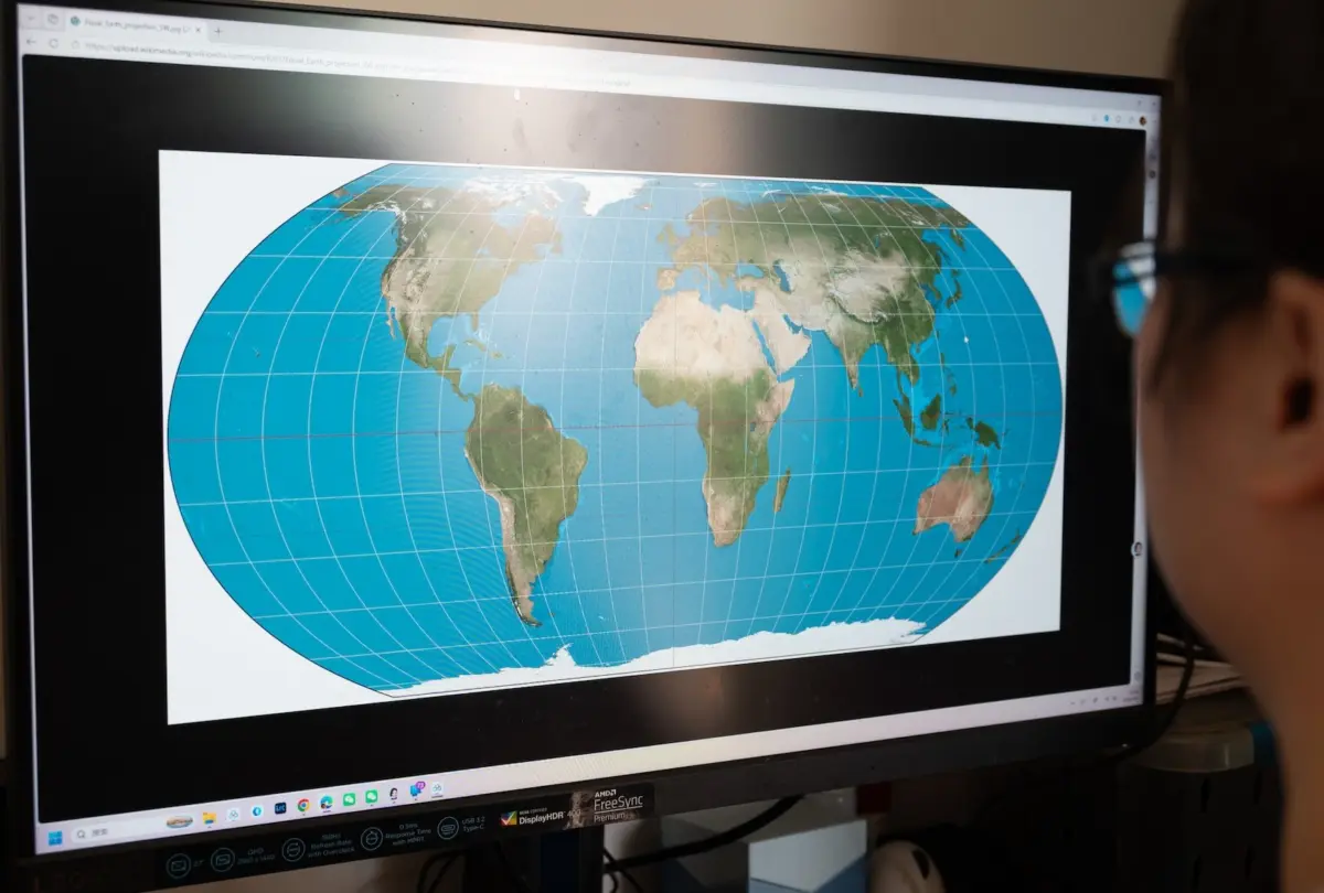
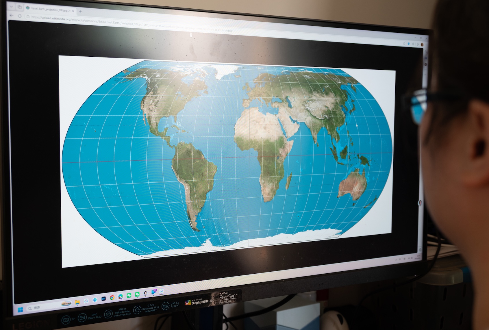
In an international vote that highlights the widening chasm between objective science and modern geopolitical grievance, the United Nations General Assembly recently endorsed a non-binding resolution promoting the "Equal Earth" map projection. Spearheaded by the West African nation of Togo, the initiative aims to phase out the pervasive geographical distortions of the 16th-century Mercator projection—most notably its dramatic inflation of the Northern Hemisphere and its severe minimization of the Global South.
The vote passed with an overwhelming, near-unanimous consensus of 164 countries in favor, six abstentions, and precisely one vote cast in opposition: the United States.
Rather than treating the vote as a routine, technical modernization of global cartography, Washington’s diplomatic corps treated the non-binding advisory as an existential threat. In a blistering explanation of vote, U.S. representatives condemned the initiative not as an update to geographic proportions, but as a Trojan horse for "reparations" and "cognitive justice."
This analysis examines why a basic adjustment to world map proportions struck such a raw nerve in American foreign policy. By placing this vote within the broader framework of anti-multilateralism, historic colonial nostalgia, and modern populist political signaling, it becomes clear that the U.S. rejection of the "Correct the Map" plan is symptomatic of a broader retreat from consensus reality.
Detailed Chronology: From 16th-Century Navigation to a Global Diplomatic Showdown
The Mercator Legacy and Its Inherent Flaws
To understand the diplomatic firestorm, one must first look at the tool in question. Commissioned in 1569 by Flemish geographer Gerardus Mercator, the Mercator projection was designed as a navigational aid for sailors. By rendering lines of constant course as straight segments, it solved critical challenges for European maritime explorers crossing the globe during the age of sail.
However, translating a three-dimensional sphere onto a two-dimensional flat rectangle requires mathematical compromise. The Mercator projection achieves this by aggressively expanding landmasses as they move further away from the equator.
The consequences of this mathematical inflation are profound and politically skewed. Because Europe and North America sit comfortably in the upper latitudes, they appear vastly larger than they actually are. Greenland, for instance, appears roughly equivalent in size to the entire continent of Africa on a standard Mercator map. In objective reality, Africa is approximately 14 times larger than Greenland. Similarly, the African continent is visually compressed, making it look comparable to North America, despite being significantly larger.
For decades, geographers, educators, and global equity advocates have pointed out these discrepancies. The issue even entered popular culture in a famous 2001 episode of The West Wing, where fictional cartographers lobbied the White House to adopt more accurate projections, demonstrating how traditional maps distort our mental model of the world’s scale and importance.
The Togo Proposal and the UN General Assembly Vote
Following years of localized adoption by schools and scientific bodies, the push for systemic reform finally reached the floor of the United Nations, courtesy of Togo. Recognizing that maps shape how young people perceive their place in the world, the West African state introduced a non-binding resolution encouraging member states and international institutions to adopt modern, area-accurate map projections—such as the Equal Earth or Gall-Peters projections—in public education and official documentation.
The vote was not a binding international mandate; it carried no enforcement mechanisms, financial penalties, or legal obligations. It was purely an advisory encouragement toward geographic accuracy.
When the ballots were tallied, 164 nations voted in favor. Six countries chose to abstain. Yet, standing entirely alone against the rest of the international community was the United States, casting a lone "no" vote that instantly drew global bafflement and ridicule.
Supporting Context & Metrics: Cartographic Distortion and Geopolitical Impact
To quantify the distortion that the United Nations sought to correct, cartographic data highlights the systemic bias baked into everyday geography:
- The Greenland-Africa Disparity: On a Mercator map, Greenland and Africa appear to be of similar geographic scale (roughly 2.1 million square kilometers vs. 30.3 million square kilometers). In reality, Africa can swallow Greenland more than 14 times over.
- The European Inflation: Europe is visually magnified relative to landmasses closer to the equator, artificially projecting a sense of sprawling dominance that distorts the true scale of the Global South.
- The Global Consensus: With 164 nations voting in favor and only the United States in opposition, the vote represents a 99% consensus among participating sovereign states—making Washington’s isolation on a purely technical mapping resolution historically rare.
The stubborn persistence of the Mercator map is not merely an educational oversight; it is deeply intertwined with the historical era of European colonialism, during which European powers placed themselves at the literal and figurative center—and top—of the world. By rejecting any move to correct these proportions, critics argue that the U.S. vote inadvertently aligns itself with the preservation of those Eurocentric imperial optics.
Official Statements: The U.S. Rationale and the Backlash
The decision of the United States to stand as the sole opponent of the resolution prompted an extraordinary official explanation from American diplomats. Yaryna Ferencevych, the deputy U.S. representative to the U.N. Economic and Social Council, delivered a sharp critique of the assembly’s priorities.
The U.S. Position
In her remarks before the vote, Ferencevych argued that the initiative could not be viewed in a vacuum, framing it as part of an ideological campaign rather than a simple cartographic update.
"While this initiative is presented as an anodyne effort to update cartographic proportions, the United States clearly sees it cannot be separated from the much larger and more radical ideological project it belongs to," Ferencevych stated.
She went on to accuse the international body of abandoning its core mission of international peace and security to debate historical grievances:
"Instead of focusing on genuine problems of international peace, prosperity, or good relations, this body is debating map projects from the 16th century, and their role in promoting reparations and ‘cognitive justice.’ Resolutions like this, and the ideological agenda they promote, are barnacles on our work here, and the reason this institution is losing its credibility."
The International Reaction
Ferencevych’s defense struck many international observers as an overreaction of monumental proportions. Rather than neutralizing criticism, the speech highlighted how deeply sensitive American leadership has become to any multilateral initiative perceived as catering to the Global South or challenging traditional Western dominance.
Commentators worldwide noted the irony: a superpower capable of projecting military and technological might across the globe chose to expend valuable diplomatic capital picking a fight over schoolroom geography. The UN diplomatic corps responded with widespread eye-rolling, viewing the American stance as yet another instance of obstructive isolationism.
Future Outlook: Implications for U.S. Foreign Policy and Multilateralism
The U.S. vote against the "Correct the Map" resolution cannot be understood solely in terms of cartography. Instead, it serves as a micro-cosm of a broader political strategy—one heavily influenced by the MAGA (Make America Great Again) worldview, which has consistently sought to undermine, diminish, or withdraw from international institutions.
The Domestic Political Alignment
For years, right-wing populist movements in the United States have viewed the United Nations with deep suspicion, characterizing it as an anti-American bureaucracy intent on eroding national sovereignty. From past withdrawals from the World Health Organization and the Paris Climate Agreement to the creation of alternative, politically aligned bodies like the so-called "Board of Peace," the overarching goal has been to delegitimize traditional multilateral consensus.
Rejecting objective geographical reality—much like denying anthropogenic climate change, resisting empirical public health data, or embracing AI-generated disinformation—fits comfortably within a political ecosystem that prioritizes narrative and grievance over observable facts.
Furthermore, this stance echoes long-standing domestic anxieties over demographic shifts and changing global power dynamics. When a nation’s political identity is tied to an idealized, nostalgic vision of 20th-century hegemony, even a minor symbolic shift that elevates the visual scale and visibility of the Global South can feel threatening to conservative nationalists.
The Cost of Isolation
While the U.S. maintains the power of the veto within the United Nations Security Council—a privilege shared with Russia, China, France, and the United Kingdom—it could not exercise that veto power over a General Assembly advisory vote concerning cartography. Consequently, the resolution passed comfortably despite Washington’s objections.
However, symbolic votes matter. Stunts that position the United States as an outlier on basic, objective facts do not project strength; they project insecurity and unseriousness. When 164 nations agree on a basic step toward geographical accuracy and scientific honesty, a lone superpower refusing to participate in reality looks increasingly isolated.
As the international community grapples with massive, highly consequential crises—ranging from global economic shifts to transnational security threats—the ability of the United States to lead depends heavily on its credibility, rationality, and willingness to engage constructively with the rest of the world. By picking a fight with a schoolroom map, Washington sent an unmistakable signal: when it comes to acknowledging the changing world, the U.S. would rather stay firmly locked in the 16th century.
