

Executive Overview
NASA scientists are closely monitoring an exceptionally powerful El Niño event that is currently unfolding across the equatorial Pacific Ocean. According to cutting-edge satellite observations and data processed by the Jet Propulsion Laboratory (JPL), this rapidly developing climate phenomenon is tracking to match—and potentially exceed—the historic, paradigm-shifting El Niño event of 1997–1998, which permanently altered modern understandings of global weather forecasting.
The current event has captured the intense scrutiny of the global scientific community. Leveraging an unprecedented 35-year continuous observational record provided by satellite altimetry, researchers can evaluate the trajectory of the 2026 event against some of the most potent climatic anomalies ever recorded in human history. The stakes are profoundly high: previous iterations of this magnitude brought widespread ecological devastation, catastrophic droughts, unprecedented agricultural failures, and extreme coastal flooding across multiple continents.
National Oceanic and Atmospheric Administration (NOAA) forecasts reinforce these rising concerns, projecting an 83 percent probability that strong-to-very-strong El Niño conditions will persist through the first quarter of 2027. While modern satellites offer an unprecedented window into the mechanics of ocean-atmosphere coupling, climatologists warn that predicting precise, localized impacts remains a complex challenge. As the world braces for the potential fallout of this climate titan, researchers are racing to decode the subtle signals encoded in sea-surface heights before its full force reshapes global weather systems in the winter of 2026–2027.
Detailed Chronology: The Evolution of a Global Climate Driver
El Niño is a recurring, naturally occurring climate phenomenon that typically develops every two to seven years. It is fundamentally characterized by a sustained rise in ocean surface temperatures across the central and eastern equatorial Pacific. When these massive thermal anomalies occur, they fundamentally disrupt normal atmospheric circulation, triggering a cascade of secondary weather shifts that reverberate far beyond the Pacific basin.
To understand the trajectory of the current event, climatologists look back at recent historical benchmarks, most notably the twin powerhouses of 1997–1998 and 2015–2016. Both of those occurrences left indelible scars on global infrastructure and ecosystems. The 1997–1998 event triggered destructive, out-of-control wildfires across the rainforests of Indonesia and the Amazon, devastated agricultural yields through severe droughts in southern Africa, and battered the coastlines of Southern California with relentless, torrential rainfall and devastating storm surges. Nearly two decades later, the 2015–2016 El Niño proved similarly disruptive, shifting precipitation corridors and driving severe flooding across Mexico, Central America, and the southeastern United States.
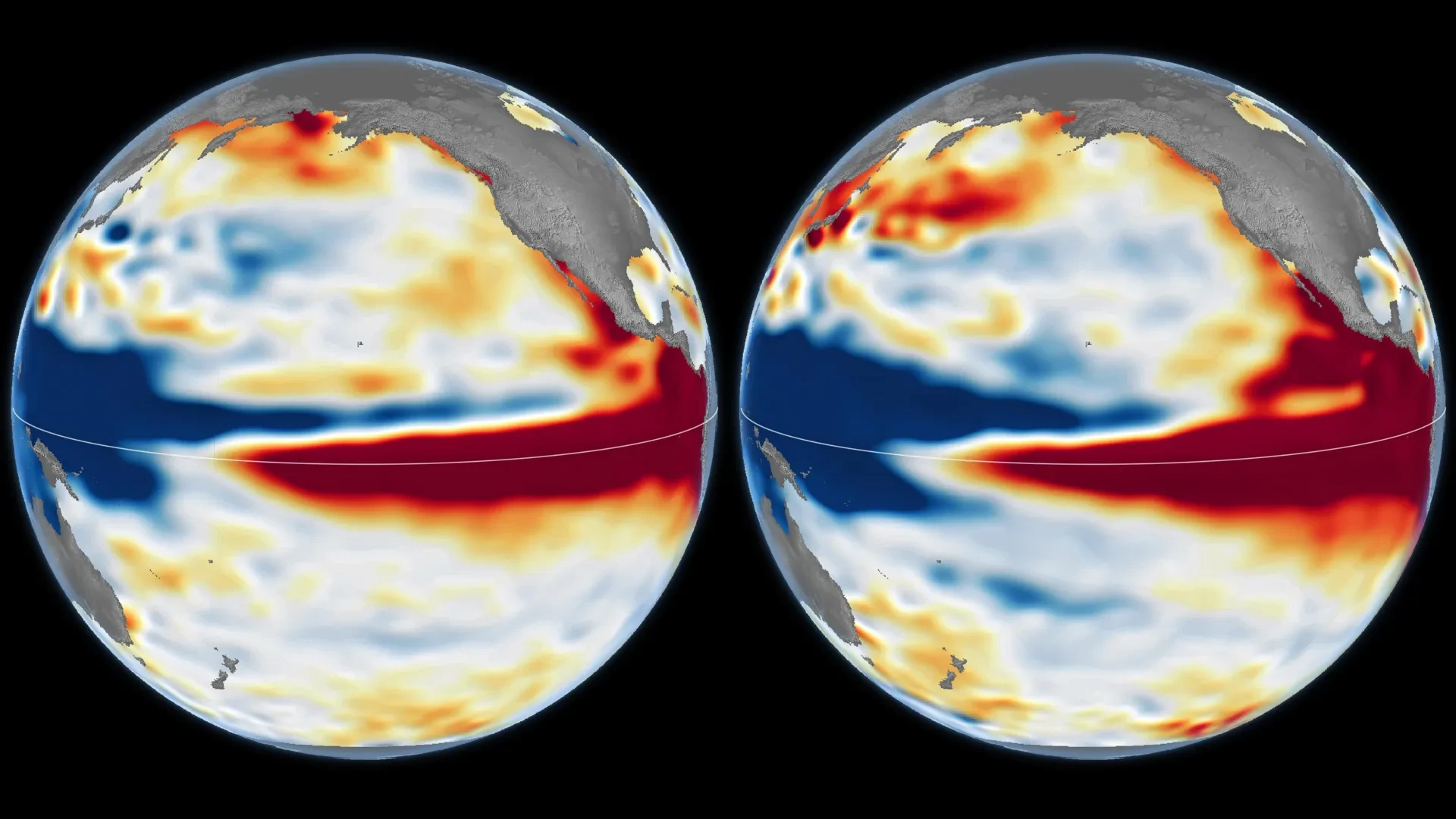
The 2026 event, however, has charted a distinct developmental course. While the 1997–1998 event built its intensity over a longer runway, the 2026 El Niño intensified with startling, uncharacteristic abruptness. Despite this variance in its early-stage timing, NASA’s orbital observations from October 2026 revealed staggering structural and thermal similarities to the legendary 1997 event.
In both instances, the Pacific Ocean displayed a pronounced, polarized topography: exceptionally low sea levels in the western basin coupled with towering, warm-water bulges in the east. This signature configuration shows massive volumes of superheated water stretching aggressively eastward along the equator until slamming directly into the western coast of South America. As scientists analyze these overlapping timelines, the central question remains whether the 2026–2027 winter will mirror the dramatic meteorological disruptions seen nearly three decades prior.
Supporting Context & Metrics: Unlocking the Mechanics of Altimetry
The capacity of modern science to track and evaluate these aquatic anomalies rests on decades of technological innovation, specifically the deployment of space-borne satellite altimetry.
The Physics of Pacific Warming
Under normal, non-El Niño conditions, steady easterly trade winds sweep across the tropical Pacific, pushing warm surface waters westward toward Asia and Australia. This continuous displacement causes warm water to pile up in the western Pacific, creating an ocean surface that sits measurably higher than its eastern counterpart.
However, when these trade winds mysteriously weaken or temporarily reverse direction, the systemic equilibrium collapses. The accumulated warm water in the west begins surging eastward across the equatorial basin in massive subsurface waves known as Kelvin waves. As this thermal mass migrates, it further suppresses the trade winds, creating a self-reinforcing feedback loop. Sea levels rise significantly across the central and eastern Pacific, and massive amounts of ocean heat are liberated into the atmosphere.
35 Years of Orbital Continuity
The breakthroughs enabling researchers to decode the 2026 El Niño stem from an unbroken, 35-year archive of sea-surface height measurements. Because water expands thermally as it warms, tiny fluctuations in ocean elevation captured from space serve as a direct proxy for ocean heat accumulation.
The empirical foundation for this research relies on a seamless relay of successive satellite missions flying virtually identical orbital ground tracks. Historical baseline data from the historic 1997 event was collected by the joint NASA/CNES TOPEX/Poseidon satellite. For the 2015 event, observations were pulled from the Jason-2 mission. Today, the modern 2026 data stream is powered by the Sentinel-6 Michael Freilich satellite, alongside other advanced Earth-observing platforms.
[TOPEX/Poseidon (1997)] ──> [Jason-2 (2015)] ──> [Sentinel-6 Michael Freilich (2026)]
        │                           │                               │
        └───────────────> [35-Year Continuous Altimetry Record] <───────┘
By ensuring that each satellite mission overlapped its predecessor with meticulous calibration, JPL researchers have eliminated calibration gaps. When scientists processed side-by-side comparison maps of the Pacific Ocean on October 13, 1997, and October 12, 2026, they utilized specialized filtering algorithms to strip away seasonal variations and long-term climate change trends. The resulting visualizations—which employ stark red hues to designate anomalous sea-surface height elevations—reveal a developing climate event that matches the structural footprint of 1997 while threatening to surpass its raw spatial scale.
Official Statements and Scientific Perspectives
The complexities of comparing modern climate anomalies to historical milestones have drawn cautionary yet fascinated commentary from the researchers leading NASA’s sea level and climate monitoring initiatives.
"The search for the ‘typical’ El Niño is very elusive," explains Josh Willis, project scientist for sea level missions at NASA’s Jet Propulsion Laboratory in Pasadena, California. "They’re all different in terms of where they land and how their impacts play out."
Despite these inherent variabilities, the unprecedented clarity of modern satellite records has given scientists high confidence in evaluating the sheer magnitude of the unfolding event.
"What’s unique about altimetry is that we have a 35-year record from nearly identical satellites flying almost the same ground track, with each mission overlapping the next," Willis emphasizes. "That lets us look back in time and compare this El Niño to what happened in 1997. And right now, this one is on track to be even bigger."
At the institutional level, official outlooks have underscored the mounting urgency. In an official advisory released on October 8, 2026, the Climate Prediction Center of the National Oceanic and Atmospheric Administration (NOAA) calculated an 83 percent statistical likelihood that strong-to-very-strong El Niño conditions will firmly anchor themselves across the globe through the first quarter of 2027.
Nevertheless, institutional experts remain careful not to overpromise localized impacts. NOAA and NASA scientists alike note that while the overarching marine architecture of the 2026 El Niño closely mimics historical precursors, structural differences—such as those observed during the structurally distinct 2015–2016 event, where warm water failed to fully breach the South American coastline with equal ferocity—demonstrate that similar marine profiles can yield wildly divergent atmospheric outcomes.
Future Outlook: Winter 2026–2027 and Beyond
As the calendar turns toward the peak months of the winter season, governments, agricultural cartels, disaster management agencies, and meteorologists are bracing for the potential fallout of the 2026–2027 El Niño.
The primary challenge moving forward lies in the fundamental physics of teleconnections—the complex, often chaotic ways that tropical Pacific heat exchanges translate into localized weather changes thousands of miles away. While changes in the tropical Pacific dictate broad atmospheric shifts, the exact placement of jet stream adjustments, severe storms, droughts, and torrential floods becomes increasingly difficult to forecast the further one moves from the equator.
Other chaotic atmospheric phenomena, including the Arctic Oscillation and unpredictable marine heatwaves in other ocean basins, can interfere with, amplify, or blunt the expected signature impacts of a strong El Niño. Consequently, while the historical parallel to 1997 offers an invaluable template for emergency preparedness, it does not serve as an infallible script for the months ahead.
"There’s always a bit of a dice roll here," Willis cautions, summarizing the humbling reality of long-range climate forecasting. "Just because this El Niño looks like 1997 doesn’t mean it will be exactly the same—it’s just our best guess at the moment."
Ultimately, the 2026 El Niño serves as both a profound stress test for global infrastructure and a triumphant validation of decades of investments in Earth-observing satellite architecture. Whether the coming months bring the drought-breaking rains of a classic strong event or unexpected meteorological divergences, the relentless eyes in orbit will continue tracking every centimeter of rising water, providing humanity with vital time to adapt to a rapidly shifting global climate.
