

Executive Overview
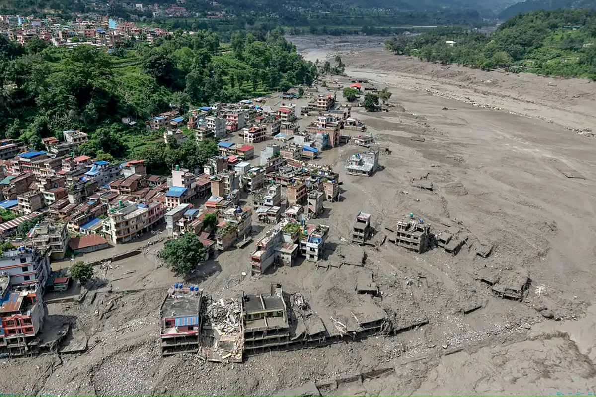
In the high-altitude crucibles of the Himalayas, where jagged peaks pierce the clouds and ancient ice fields carve out valleys, a catastrophe of staggering proportions unfolded with terrifying speed. A catastrophic flash flood struck Nepal, leaving a trail of unimaginable devastation in its wake. The initial casualty estimates and missing-persons reports painted a grim picture, with over 1,000 confirmed dead and thousands more unaccounted for. In the immediate aftermath, as frantic rescue operations began, rumors and unverified information rippled across digital networks—including AI-generated fabrications that complicated disaster response efforts.
Yet, beneath the noise of social media speculation, a more complex and scientifically profound reality was taking shape. While early theories pointed toward seismic disturbances or standard glacial lake outbursts, a global coalition of geologists, geophysicists, and glaciologists utilizing high-resolution satellite imagery soon arrived at a chilling conclusion. This was not a conventional flood. Instead, it was a rare, violent hybrid phenomenon: a colossal mountainside collapse carrying an entire fragment of a glacier on its back.
As the massive slurry of rock, pulverized earth, and liquefied ice roared down the steep inclines of the Himalayas, it achieved hyper-velocity, reaching the first populated valley floor in a mere seven minutes. The sheer kinetic energy of the descent generated intense friction, rapidly melting internal and surface ice to supercharge an already catastrophic wall of water.
Now, as governments look toward recovery and international accountability, scientists are racing to understand the mechanics of this disaster. Pointing to degrading permafrost, shifting precipitation patterns, and decades of regional warming, experts warn that this event—much like the Chamoli disaster in India four years prior—is a harbinger of a volatile new normal in high mountain environments. With Nepal formally seeking $5 billion in climate adaptation and disaster relief aid from the United Nations, the international community faces an urgent imperative: decode the triggers of these mountain collapses and deploy advanced early-warning systems before the next peak gives way.
Detailed Chronology: Anatomy of a High-Altitude Disaster
To understand how a tranquil mountain landscape transformed into a raging torrent within minutes, researchers have reconstructed the timeline of the disaster using orbital satellite passes, seismic monitoring stations, and survivor accounts.
The Trigger: Structural Failure at High Altitude
Weeks before the catastrophic floodwaters breached the valleys, microscopic changes were occurring deep within the bedrock of the Himalayan peak. Years of rising ambient temperatures had begun to compromise the mountain’s permafrost—the ancient, frozen cement of ice, soil, and rock that holds steep alpine slopes together.
As this permafrost thawed, seasonal meltwater and recent precipitation seeped deep into tectonic fractures and micro-fissures within the rock face. As temperatures fluctuated, this water repeatedly froze and thawed, exerting immense wedge-like pressure on the stone. By the time the critical threshold was reached last week, the structural integrity of the mountainside had been fatally undermined.
The Collapse and the "Glacial Ride"
Rather than a slow, incremental creep, the failure was catastrophic and instantaneous. A massive chunk of the mountainside—spanning an immense volume of rock and earth—sheared away from the ridge.
Crucially, this falling mass did not miss the surrounding cryosphere. Situated directly atop and adjacent to the collapsing bedrock was a massive section of a high-altitude glacier. When the foundation gave way, it dragged a massive piece of the glacier down with it.
As this combined monolith of granite, sediment, and glacial ice plunged downward, it initiated an ice avalanche of unprecedented proportions. Physicists analyzing the event note that the sheer potential energy of the high-altitude slope converted rapidly into kinetic energy.
The Seven-Minute Rush
As the colossal landslide-avalanche hybrid careened down the narrow valleys, it behaved less like a standard mudslide and more like a fluid avalanche. According to University of Michigan geophysicist Marin Clark, the speed of the descending material was staggering.
"It reached the first affected town in only seven minutes," Clark notes.
During this frantic descent, the extreme friction generated by millions of tons of rock and ice grinding against the valley walls caused instantaneous thermal heating. This friction rapidly melted the ice within the debris flow, as well as the snowpack and ice it encountered along its path. The result was a monstrous volumetric expansion of water, transforming a terrestrial landslide into a raging, sediment-laden flash flood that scoured the valley floor bare of infrastructure, vegetation, and human habitation.
Supporting Context & Metrics: Science Behind the Catastrophe
The disaster in Nepal has forced the global scientific community to re-evaluate the specific mechanics governing high-mountain stability in an era of rapid climate shifts.
Deconstructing the Misconceptions: Glacial Lake Outburst Floods (GLOFs) vs. Rock-Ice Avalanches
In past decades, when sudden, destructive floods emanated from the Himalayas, researchers and local authorities almost universally blamed Glacial Lake Outburst Floods (GLOFs). GLOFs occur when moraine dams—mounds of debris left behind by retreating glaciers—fail under the pressure of expanding meltwater lakes, sending walls of water downstream.
However, Dr. Daniel Shugar, a geologist at the University of Calgary, emphasizes that the recent Nepal disaster defies this traditional categorization.
"This is a similar kind of thing to the 2021 Chamoli disaster in India, where you have this flood downstream and nobody initially knew what it was or what caused it," Shugar explains. "People thought it must be a glacial lake outburst flood, but it was a landslide with a piece of glacier on top that collapsed and melted all of the ice."
The Role of Permafrost and Precipitation Shifts
The integrity of high-altitude ecosystems relies heavily on permafrost. When permafrost thaws, slopes that have remained stable for millennia suddenly lose their adhesive strength.
Furthermore, Shugar points out that meteorological shifts are exacerbating these subterranean vulnerabilities. Changes in regional seasonality—specifically a shift from heavy winter snowpacks to liquid winter and spring rains—introduce unprecedented volumes of free-flowing water into the mountain substrates. When liquid water penetrates rock fractures, it increases pore-water pressure, effectively greasing the skids for massive slope failures.
Global Scientific Collaboration in Real-Time
In the wake of the disaster, a decentralized digital coalition of researchers mobilized instantly. Shugar highlights the role of modern communication tools in modern geosciences:
"A couple dozen other scientists are working on this research together, around the world. There’s a Slack channel where they share satellite images and observations. It’s a global community of scientists volunteering our time, expertise, and skills to cooperate on figuring this out."
By pooling orbital radar data, optical satellite imagery, and seismic wave signatures, this international network is mapping the exact epicenter of the collapse, calculating the total volume of displaced earth, and refining models to predict where similar vulnerabilities may exist across the Himalayan arc.
Official Statements and Socioeconomic Fallout
The human toll of the disaster has sent shockwaves through the geopolitical landscape of South Asia, prompting immediate policy responses and demands for international climate justice.
Nepal’s Appeal to the Global Community
With over 1,000 lives lost and economic infrastructure in ruins, the government of Nepal has pointed directly to global climate change as the fundamental driver behind the catastrophe. The disaster has devastated regional agriculture, wiped out hydroelectric projects, and displaced countless families.
In response to the crushing financial burden of rescue, relief, and long-term reconstruction, Nepal has formally applied for $5 billion in financial assistance from the United Nations climate fund. This funding request underscores a growing friction between developing nations in climate-vulnerable geographies and the industrialized nations historically responsible for the majority of global greenhouse gas emissions.
The Attribution Challenge
While policymakers and affected nations point readily to global heating, scientists remain academically rigorous regarding direct attribution. As Marin Clark observes:
"We have a lot of trouble attributing any one specific event to climate change. But what we do know is that the warming conditions we’ve seen in the Himalayas over the last several years are exactly the kind that can lead to processes like what we observed last week."
Data compiled over the past decade indicates a clear statistical trend: large, sediment-laden, high-altitude floods and slope failures are increasing in frequency across the Hindu Kush Himalaya region. Whether viewing the disaster through the lens of localized thermodynamics or planetary atmospheric shifts, the consensus remains that baseline environmental conditions in the mountains have fundamentally destabilized.
Future Outlook: Mitigation, Early Warning, and Resilience
As search-and-rescue operations slowly transition into recovery and infrastructural assessment phases, experts are turning their attention to the inescapable question: How do we prevent this from happening again?
The Imperative of Early-Warning Systems
Given the sheer speed at which hybrid rock-ice avalanches can traverse mountain valleys—covering miles in mere minutes—traditional evacuation procedures triggered by visual confirmation are entirely inadequate.
"Early warning is probably the highest priority," asserts Dr. Clark. "Developing systems that recognize the seismic signals that may be the initial trigger, giving communities downstream enough time to evacuate to higher ground and enough time for workers to get out of tunnels."
Implementing such systems requires a massive capital investment in high-altitude sensor networks. Seismic monitors, infrasound detectors, and automated stream-gauge monitors must be deployed near vulnerable glacial tongues and unstable permafrost slopes. When a structural shift or slope-failure tremor is detected, automated sirens can be triggered in valley settlements below, buying precious minutes for human life preservation.
Engineering in a Warming World
Beyond early-warning sirens, civil engineers working in the Himalayan region must rethink infrastructure design standards. Hydropower facilities, roads, bridges, and settlements built in historical floodplains are increasingly untenable. Relocating critical infrastructure to higher elevations, constructing massive diversion barriers, and restricting development in high-risk glacial valleys will be vital steps for regional survival.
A Warning to the World
The catastrophe in Nepal serves as a sobering reminder of the interconnected nature of earth systems. When high-altitude ice fields and permafrost degrade, the consequences do not stay trapped on remote mountain peaks—they cascade downward into densely populated river basins with devastating velocity. As global temperatures continue to climb, the international scientific community’s race to map, monitor, and protect the roof of the world has never been more urgent.